Restoring Wetlands Through the Lens of Cultural Heritage
World Wetlands Day, celebrated on February 2nd, has a theme of "Wetlands and traditional knowledge: Celebrating cultural heritage." It is focused on the crucial role of indigenous, local ancestral wisdom in sustaining wetlands and preserving cultural identity, linking past practices with scientific stewardship. On this theme, several science and art institutions in the US and Australia collaborated to prepare science and art exhibits, educational events, and social media campaigns to promote awareness and action on the Ramsar Convention on Wetlands during the 250th anniversary of America.
The Ramsar Convention on Wetlands, an international treaty
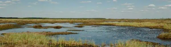
The Ramsar Convention on Wetlands mandates the conservation and wise use of all wetlands, which includes - all lakes, rivers, swamps, marshes, peatlands, deltas, mangroves, coral reefs, and human-made sites like rice paddies - promoting sustainable development and international cooperation, especially for waterfowl habitats.
As of early 2026, 172 countries, almost 90% of UN member states, are Contracting Parties to the Ramsar Convention, forming a global framework for wetland conservation. These nations manage the world's largest network of protected wetlands, known as Ramsar Sites, totaling over 2,520 sites covering more than 253 million hectares (625 million acres) and designated to conserve biological diversity and promote wise wetland use for sustainable development.
Ramsar Convention requires member countries, which include Australia (1971) with 67 Ramsar Sites and the US (1986) with 41 Ramsar Sites, to designate "Wetlands of International Importance", protecting them for biodiversity, cultural, economic, and scientific value, recognizing wetlands' critical roles for water, biodiversity, and human well-being.
Despite near-universal adoption, adherence to the Ramsar Convention on Wetlands is often described as inconsistent. For example, the High Court of Australia has generally upheld the Commonwealth’s power to enforce international environmental treaties.
The US Supreme Court on the other hand, in May 2023 with its Sackett v. EPA ruling significantly weakened federal protection for wetlands under the U.S. Clean Water Act (CWA) by establishing that only wetlands with a "continuous surface connection" to traditionally navigable waters (like rivers, lakes, oceans) are federally protected, effectively removing the broader "significant nexus" test that covered many isolated wetlands, which has led to the potential loss of federal oversight for millions of acres and shifted more regulatory burden to states, though this ruling’s direct impact on the international Ramsar Convention is indirect, primarily through reduced U.S. commitment to federal wetland protection. This decision reversed previous standards, reducing federal oversight and potentially opening many wetlands to development, placing greater responsibility on states for their protection.
Read More: World Wetlands Day: Preserving Our Natural Heritage.
Lamont-Doherty Earth Observatory of Columbia University (LDEO), Palisades, NY
The LDEO, a renowned research institute of Columbia University, specializes in studying Earth's natural systems. LDEO scientists were among the first to map the seafloor, provide proof for the theory of plate tectonics and continental drift, and develop a computer model that predicted El Niño events. LDEO’s research covers everything from the formation of the Earth, moon, and solar system to the movement of carbon and other materials through the Earth System, including its atmosphere, oceans, and land, using different types of Earth materials from sediments to cave deposits to tree rings to identify past climate shifts and changes.
LDEO along with NASA collaboratively study wetlands through a blend of high-tech remote sensing (satellites, radar) for large-scale mapping and ground-based fieldwork, using sediment cores, water/biological sampling (pollen, eDNA), and detailed field measurements to understand water levels, vegetation changes, sediment dynamics, and contaminant impacts, often focusing on regional areas like the NYC Coastal Wetlands, the Hudson River Estuary to monitor crucial ecological changes.
Dr. Dorothy Peteet, Senior Research Scientist and head of the Paleoecology Group of the New Core Lab at the LDEO, and at the NASA Goddard Institute for Space Studies (GISS), explained
"Under the Supreme Court’s "Continuous Surface Connection" test, wetlands must physically touch or be indistinguishable from a covered water body (like a river or lake) to fall under CWA jurisdiction. Many isolated wetlands, those connected only by groundwater, or ephemeral (seasonal) streams lost federal protection and there are many of these in New York. Estimates suggest millions to tens of millions of acres of wetlands lost federal oversight with now States creating or strengthening their own programs to protect these newly unprotected wetlands. The lack of federal oversight increases the risk that these ecologically significant areas, including Ramsar Sites, like NY’s Niagara River Corridor, recognized for its immense biodiversity and ecological importance as a transboundary wetland, could degrade or disappear. The ruling creates opportunities for development in areas previously subject to strict federal environmental review.
I saw warehouses, industrial developments built on wetlands of Staten Island near the Saw Mill Creek Marsh that was part of Lenapehoking, the ancestral homeland of the Native American tribe Lenape people. Wetlands are the “lungs of the earth" playing critical roles in filtering water, controlling floods, buffering sea level rises, supporting biodiversity, sequestering heavy metals and storing vast amounts of carbon, making them vital for a healthy planet, even more so than rainforests in some respects, as they act as powerful carbon sinks and natural water purifiers.
The Shinnecock Indian Nation on eastern Long Island on the other hand which lost wetlands to Hurricane Sandy implemented a large-scale, nature-based ancestral shoreline restoration project, using native plants, dredged sand, and strategically placed oyster clusters and rocks instead of seawalls [or industrial development projects] to build resilient dunes and habitats, reflecting a commitment to working with nature for long-term wetland preservation and adaptation.”
Professor Steven Goldstein, the Interim Director at LDEO, who instituted a science-art initiative, noted that
“The LDEO acknowledges its location on Lenape ancestral lands (Lenapehoking) with a core mission focused on fundamental Earth science research and strong educational outreach. I have encouraged using science and art together to communicate to the broad public the critical role of geoscience in our understanding of how wetlands work, which must serve as the basis for finding solutions to wetland restoration.”
Art Meets Science
National Lighthouse Museum (LLM), Staten Island, NY
Staten Island's wetlands, once used as the world’s largest wastelands, are now crucial ecosystems being restored, particularly at Freshkills Park, which was a landfill until 2001 but since 2008 has been becoming parkland featuring tidal marshes vital for wildlife, echoing the historical use by the Native American tribe Lenape.
This ancestral restoration project benefits from research by scientists like Dr. Dorothy Peteet, a leading expert in using paleoecology to inform the restoration of "ancestral" or historical wetlands and in studying peat layers to understand past ecosystem health, linking modern conservation efforts to the ancient landscapes of the Lenape People.
Freshkills Park Project, which is expected to be completed in various phases by 2036, is an expanse of grasslands, creeks, and rolling hills in Staten Island, the southernmost borough in New York City, which will be nearly three times the size of Central Park and the largest green space to open in the city in 100 years.
The Freshkills Park Alliance and NYC Parks acknowledge that the park's location on Staten Island is the ancestral homeland of the Lenape People known as Lënapehòkink. They were deeply connected to wetlands, rivers, and the land for millennia, living in harmony with nature through semi-permanent villages near water, using local resources for food, shelter (wigwams), and medicine for more than 10,000 years. They used Freshkills Park for hunting and fishing, calling Staten Island Aquehonga Manacknong, meaning "place of bad wood,s" a name reflecting its dense, perhaps difficult, forested terrain.
Linda Dianto, the Executive Director of the National Lighthouse Museum (NLM), explained
that the museum's core is lighthouses, its location on the waterfront of ancient Lenape land connects it to the broader waterfront revitalization efforts that is restoring the ancestral harbor ecosystem of NY[1] and NJ[2] which emphasize transforming industrial brownfields into community-centric and resilient living shorelines with marshes and the vital ecosystems, including wetlands of New York Harbor with its Billion Oyster Project that our museum supports.
We invite everyone who wants to see America 250-themed art exhibitions opening on January 25 and the largest waterfront spectacle, SAIL 4th 250…Where Light Meets Liberty! that will take place from July 3-8, 2026, in the Port of New York and New Jersey, with the main spectacle, the International Parade of Tall Ships, scheduled for July 4, 2026.
The event is part of America's Semiquincentennial (250th) anniversary celebration and is expected to be the largest international maritime gathering in U.S. history, with over 30 tall ships from around the world, sailing up the Hudson River. Our museum willserve as a key viewing spot.”
Havre de Grace Maritime Museum & Environmental Center (HDGMM) Havre de Grace, MD
The Chesapeake Estuary is North America's largest estuary, a vital, brackish body of water where fresh river water mixes with Atlantic saltwater, creating a rich wetland habitat for over 3,600 species and supporting massive seafood production and economies, though it faces significant threats from pollution, habitat loss, and overfishing, prompting large-scale restoration efforts by its vast watershed.
It is protected by the 2026 Chesapeake Bay Watershed Agreement that protects wetlands in six states (MD, VA, PA, DE, NY, WV, plus DC) by setting new goals for habitat, pollution reduction (N, P, sediment), and land conservation, focusing on restoring 3,000 acres of wetlands by 2040, improving shoreline erosion management with living shorelines, and formally engaging Indigenous tribes, using science-based adaptive management for thriving habitats, clean water, and sustainable communities across the entire watershed.
In essence, the 2026 Chesapeake Bay Watershed Agreement integrates wetlands into broader land ancestral restoration efforts, aiming to protect riparian buffers and natural areas, all while reducing pollution, building climate resilience, and using data-driven approaches to maintain these vital habitats for water quality and wildlife.
Jennifer Sim, the Executive Director of the HDGMM, explained
Our museum is located at the mouth of the Susquehanna River where it meets the Chesapeake Bay. The primary Native American tribe that lived in this area for centuries was the Susquehannock, an Algonquian-speaking giant-like people with deep voices known for their palisaded villages. Their ancestral traditional knowledge is being integrated into modern wetlands restoration efforts in this region, particularly through the revitalization of the shoreline.
The Environmental Center of our Museum uses grants from the Chesapeake Bay Trust to support wetland and riparian restoration projects through education, exhibitions, outreach, and participatory science programs to transform industrial bulkheads into living shorelines, creating tidal marsh and dune habitats, by using nature-based stormwater features to filter pollutants entering the Chesapeake Bay.
Havre de Grace has become a model for coastal resilience through significant underwater plant (Submerged Aquatic Vegetation or SAV) monitoring, and large-scale wetland restoration has seen a massive rebound of SAV, including species like wild celery, redhead grass, and sago pondweed. These plants are responsible for neutralizing acidic water conditions.”
Lord Howe Island Museum (LHIM), Lord Howe Island, Australia
Lord Howe Island (LHI) is a UNESCO World Heritage-listed volcanic ecosystem settled by Māori and Pacific Islanders, who form the basis of the current population and often consider themselves the island's indigenous inhabitants due to their long lineage.
LHI has implemented an extensive ecological restoration program, largely driven by resident-led conservation efforts and a successful 2019 Rodent Eradication Project. The project successfully removed invasive black rats and mice, which had previously decimated native species, leading to a significant recovery of the endangered Lord Howe Woodhen (population increased from 200 to over 2,000 in five years) and other endemic birds, invertebrates, and plants.
Efforts incorporated community involvement and concepts like kaitiakitanga to manage its sensitive habitats, including forests and wetlands (reefs), specifically Elizabeth and Middleton Reefs, which are globally significant southernmost coral reefs and Ramsar-listed for biodiversity, supporting unique species like Black Cod and Green Turtles within the vast Lord Howe Marine Park, showcasing Australia's commitment to the Convention's goal of conserving wetlands for their ecological character and "wise use".
Kaitiakitanga is a core Māori concept of guardianship and stewardship. Highlighting its core principles of protecting resources (land, water, people) for future generations, maintaining the life force (mauri) of all things, and its deep spiritual roots in whakapapa (ancestry) and interconnectedness, often enacted through iwi/kaitiaki leadership, emphasizing proactive care, sustainability, and the holistic health of the ecosystem, not just its exploitation.
Ian Hutton, naturalist, photographer, author, and curator of Lord Howe Island Museum (LHIM), explained,
In 2002, I was appointed as the part-time curator of the Lord Howe Island Museum and have overseen and coordinated many changes during the last twenty years in this role.
I have been involved in exhibitions, initiating a number of conservation projects on the island, focused heavily on eradicating invasive plants, pests, especially rodents, to protect its World Heritage biodiversity, including bringing back species like the Lord Howe Island Stick Insect, alongside weed control and community education on safe plant choices.
While reef bleaching events have been severe (e.g., in 2024/2025), the reef shows capacity to recover as waters cool, with recent studies documenting this recovery and resilience.”
[1] - New York's Waterfront Revitalization Act (WRA) and its local programs (LWRPs) mandate consistency with state/federal coastal management
[2] - New Jersey uses its own Coastal Management Program (CMP) and Waterfront Development Law to create legally binding policies for development in the coastal zone, often involving specific agreements such as the Hoboken settlement.
Glossary Terms:
Selva Ozelli Esq, CPA is a legal and finance executive with diversified experience dealing with highly complex issues in the field of international taxation and related matters within the banking, securities, Fintech, alternative and traditional investment funds. Her first of its kind legal analyses involving tax laws, Foreign Corrupt Practices Act (FCPA), blockchain technology, solar technology and the environment and have been published in journals, books and by the OECD. Her writings have been translated into 15 languages.